Working backwards from the 09:30 gun. Say where you are parking and how long the drive is, and this gives you the time to leave and the time to be at each step.
Order of the day
How the start works
One gun, at 09:30, not staggered waves. Everyone is in an assembly zone behind the line, and the zone you belong in is colour-coded to match your race number: check the colour on the bib and stand in the matching pen. Faster zones go first, so if you are towards the back you will cross the line a few minutes after 09:30. Timing is by chip, so your time starts when you cross, not when the gun goes.
Pacers carry flags with finish times on them. Find the one nearest your target and stand near it. The Mini and Junior runs go at 12:00, well after the 10K has cleared.
Getting home
Queueing, parking and faff times are estimates, not published figures. The closure deadlines are not: those come from the council traffic order and are on the Closures tab. Everything assumes the 09:30 start holds.
The event village, start and finish are all on Knavesmire Road at York Racecourse. The roads round it go early and in stages: Knavesmire Road from midday on Saturday, Racecourse Road and Campleshon Road at 05:00 on Sunday, Bishopthorpe Road at 07:30, the city centre at 08:30. Tadcaster Road stays open all day, which is most of the answer. The question is not which car park is nearest, it is which one you can still drive out of.
Walking times are pedestrian routes over OpenStreetMap data at a steady 5 km/h, measured to the start line on Knavesmire Road. Add a few minutes for crowds, and more if you are crossing the course.
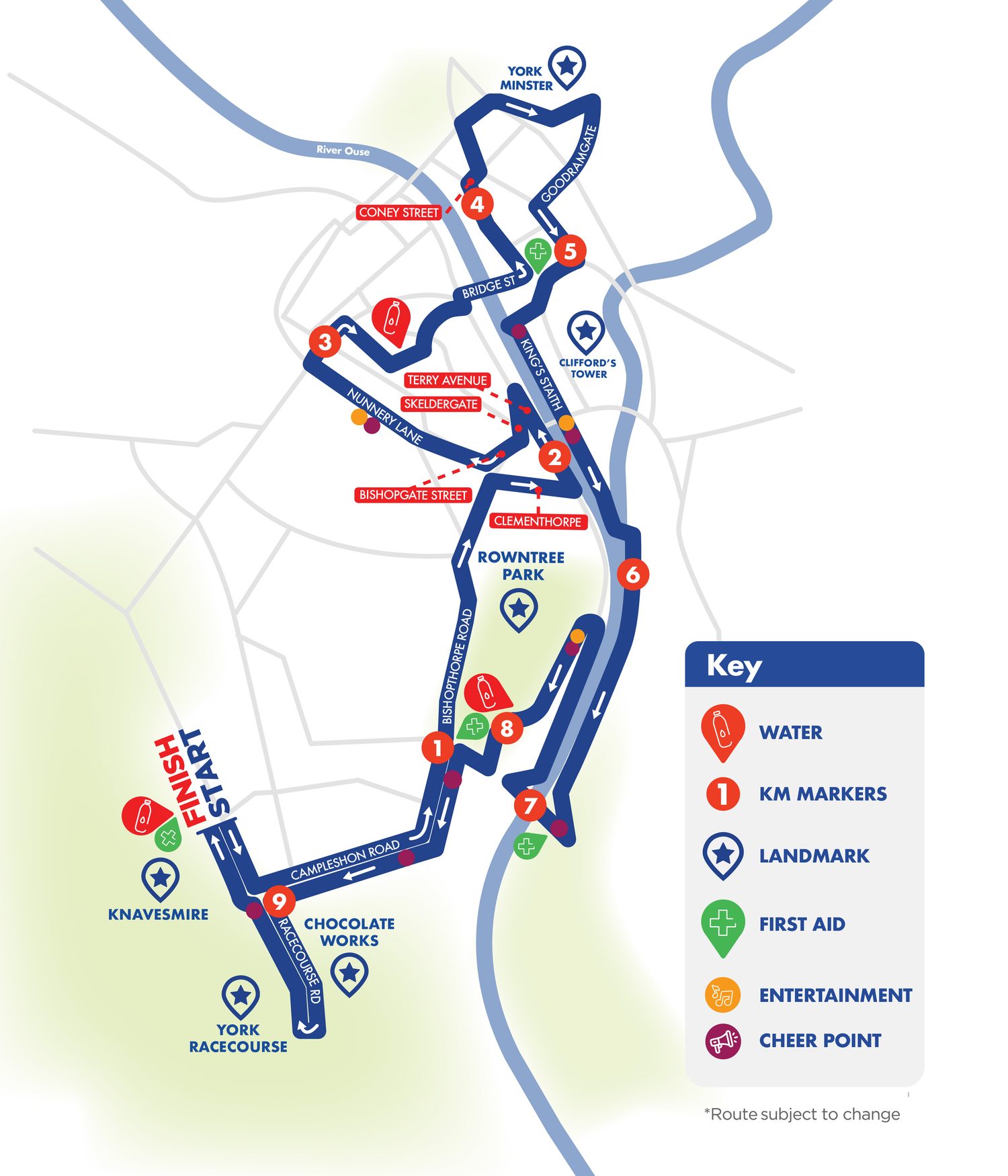
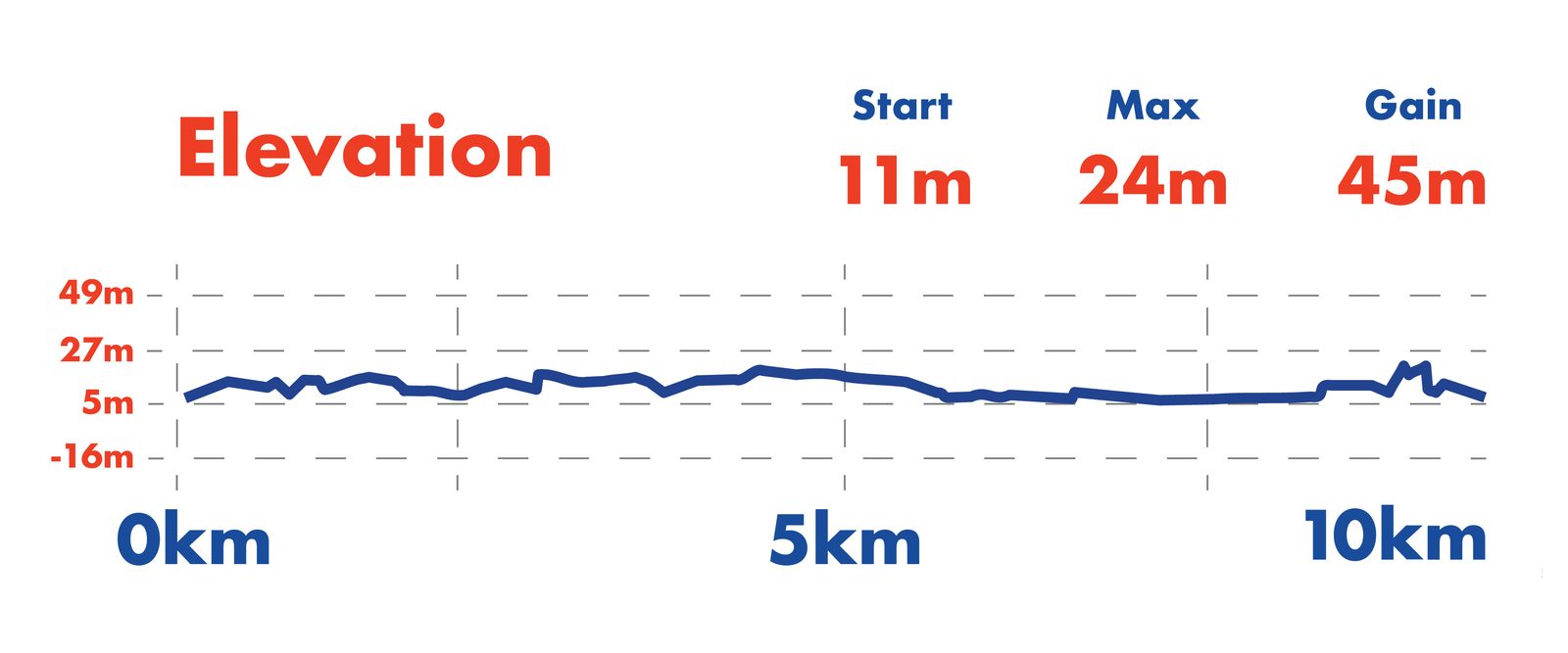
10.22 km, flat, 42 m of climb in the whole thing. Out of Knavesmire Road, east along Campleshon Road, north up Bishopthorpe Road, out to the river at Terry Avenue, then Nunnery Lane and in through Micklegate Bar. Round the Minster, down past Clifford's Tower, and south along the east bank to the Millennium Bridge. Back up Terry Avenue and Butcher Terrace, down Bishopthorpe Road and Campleshon Road, then a loop down Racecourse Road and back to the line.
The course is drawn on the Map tab in yellow, with the kilometre markers on it. It is the organisers' own GPX, not a reconstruction.
Set a finish time. Everything below follows from it, at even pace off a 09:30 start.
Kilometre splits
| Km | Where | Elapsed | Clock |
|---|
Marker positions are measured along the organisers' own GPX, which is 10.225 km against the 10.22 km they publish. Times are arithmetic off an even pace, so they will drift for anyone who does not run one.
Where to stand
The first kilometre and the last two run over the same ground, so one spot gets you the field twice. The Knavesmire Road and Campleshon Road junction gets you it three times, because the last kilometre goes down Racecourse Road and back before turning for the line. Walk times are from the finish.
Run For All run live tracking on RTRT, through their own app. It gives you split times as the runner crosses each mat, an estimated finish, and a push notification per split. It is the only live feed there is: there is no web tracker and no SMS service.
What it will and will not tell you
Timing mats are at the start, the finish, and a small number of points on course. You get a ping at each one, not a moving dot. Between mats the app shows an estimate based on the last split, so a runner who stops will look like they are still going for a few minutes.
The Splits tab is the low-tech version and it works with no signal: pick their target time, read off the clock time for each kilometre, and be standing there.
Afterwards
Chip results go up on the timing provider's site soon after the event, and on the Run For All results page. Photos are on Marathon Photos Live, searchable by race number, usually within a day or two.
Race numbers
Posted out to anyone who entered before 22 July. Otherwise collect from York Sport Village, Lakeside Way, YO10 5FG: weekdays 27 to 31 July, 10:00 to 18:00; Saturday 1 August, 12:00 to 16:00; Sunday 2 August from 07:30. The race office on the Knavesmire also does Saturday afternoon and Sunday morning, which is the one to use if you are driving in on the day anyway.
From the City of York Council traffic order. Times are approximate and subject to change. Any road crossing or joining one of these is also closed at that point, and emergency access is kept throughout.
Sunday 2 August
| Road | Section | On | Off |
|---|
Parking suspensions
| Road | Section | When |
|---|
Full order: the closure poster as issued, or Run For All's closure page.
Timings
Where each one comes from is in the right-hand column, because they are not all the same kind of fact. The traffic order times are legally fixed. The rest range from "the organisers published it" down to "this is my rule of thumb".
The Park & Ride
A dedicated service runs from Askham Bar, off the A64 on Tadcaster Road, to the Knavesmire. It is not the normal service 3 into town: it drops on Tadcaster Road at the top of Knavesmire Road, seven minutes from the start.
Tickets go through the First Bus app: Buy Tickets, region York, then scroll to the bottom for the York 10K services. Buy before you set off. Parking at Askham Bar is free; the regular Sunday service starts at 07:30, and the race service runs earlier, so check the app the night before rather than turning up on faith.
Train
York station to the start is 23 minutes on foot, up Queen Street, along Blossom Street and Mount Vale, then Tadcaster Road. That walk does not cross the course. Check for engineering works first: there is work booked between York and Newcastle in early August and Sunday morning services are thin either way.
Crossing the course
If you park north or east of the walls you have to get across the race to reach the start. Marshals hold crossing points and you will not be waved through on demand. Budget ten minutes on top, or park on the racecourse side and avoid the problem.
Baggage
The baggage store is in the event village. Tear the strip off your number and attach it to the bag. Collect as soon as you finish, before the queue builds.
Offline
This page works offline once it has been opened once over HTTPS.
What survives with no signal, after one visit:
- Everything on every tab. Parking, the plan, splits, spectator spots, the full closure table, the route and elevation images. All of it is baked into the page, so none of it needs the network.
- The map, including the course and the markers. The overlays are data, not images, so they draw with no connection.
- Map tiles you have already looked at, up to 800 of them. Everything else is grey. The Map tab has a button that pulls the whole race area in one go, 235 tiles from Askham Bar to the Minster at four zoom levels, about four megabytes. Press it on wifi the night before and the map is complete.
What does not: the closure order download, the live tracking app, the car park and results links. All of those are somewhere else on the internet.
Where this came from
Event details and the route map are from Run For All. Closures are transcribed from the City of York Council traffic order issued for the event. Street geometry is OpenStreetMap, and walking times are pedestrian routes over the same data. Check the official pages before you set off: times move.